Contaminated Site Assessment Guide
Everything you need to know about evaluating contaminated land - from Phase I desk studies through Phase III delineation and remediation planning.
A contaminated site assessment is a systematic, phased evaluation of land or property to determine whether soil, groundwater or sediment contamination exists and to quantify its extent, concentration and risk. The process follows internationally recognized standards - ASTM E1527-21 in North America and ISO 14015 globally - and progresses from a non-intrusive Phase I records review through intrusive Phase II sampling to a comprehensive Phase III delineation study when warranted. These assessments are essential during commercial property transactions, brownfield redevelopment, land use changes and regulatory compliance actions.
In British Columbia, contaminated site assessments are governed by the Contaminated Sites Regulation (CSR) under the Environmental Management Act. In the US, the EPA's Comprehensive Environmental Response, Compensation and Liability Act (CERCLA) and state brownfield programs provide the regulatory framework. This guide walks through each phase, the sampling techniques involved, regulatory requirements and how modern technology streamlines the entire process.
Why Contaminated Site Assessments Matter
Contamination on a property creates environmental, health and financial liabilities. Without a proper assessment, buyers, developers and lenders risk inheriting cleanup obligations that can exceed the property's value. The costs of ignoring contamination far outweigh the investment in a thorough assessment.
Key Drivers for Conducting Assessments
- Property transactions: Lenders require Phase I ESAs as part of due diligence before financing commercial real estate. The innocent landowner defense under CERCLA requires "all appropriate inquiries" including a Phase I ESA.
- Brownfield redevelopment: Converting former industrial land to residential or commercial use requires contamination characterization and often remediation before construction permits are issued.
- Regulatory orders: Provincial or state regulators can issue investigation orders when contamination is reported or suspected, requiring property owners to conduct assessments at their own expense.
- Land use changes: Rezoning from industrial to residential triggers assessment requirements in most Canadian provinces under contaminated sites legislation.
- Risk management: Understanding subsurface conditions protects construction workers, prevents unexpected project delays and avoids liability for spreading contamination during excavation.
Common Contaminants Found on Sites
| Contaminant Group | Common Sources | Environmental Concern |
|---|---|---|
| Petroleum hydrocarbons (PHCs) | Gas stations, fuel storage, vehicle maintenance | Groundwater contamination, vapour intrusion |
| Heavy metals (Pb, Cr, As, Cd) | Smelters, plating shops, treated wood | Soil toxicity, bioaccumulation |
| Chlorinated solvents (TCE, PCE) | Dry cleaners, metal degreasing | Dense NAPL migration, vapour intrusion |
| Polycyclic aromatic hydrocarbons (PAHs) | Creosote, coal tar, asphalt plants | Carcinogenicity, soil persistence |
| PFAS (forever chemicals) | Fire training areas, industrial sites | Extreme persistence, bioaccumulation |
| Asbestos (in soil) | Demolition debris, historical fill | Fibre release, inhalation hazard |
Phase I Environmental Site Assessment
A Phase I ESA is a non-intrusive investigation that identifies potential or recognized environmental conditions (RECs) through records review, site inspection and interviews. It does not involve sampling or laboratory analysis. The Phase I follows the ASTM E1527-21 standard in North America.
Components of a Phase I ESA
1. Records Review
The environmental professional reviews historical and regulatory records to identify past activities that may have caused contamination:
- Historical aerial photographs (typically dating back 50+ years)
- Fire insurance maps (Sanborn maps in the US)
- City directory listings showing past property uses
- Regulatory database searches (federal, state/provincial, tribal)
- Environmental lien and deed restriction records
- Previous environmental reports for the property and adjacent sites
- Geological and hydrogeological mapping
2. Site Reconnaissance
A physical inspection of the property and observable conditions on adjacent properties. The assessor looks for:
- Evidence of current or historical underground storage tanks (USTs)
- Stained soil, distressed vegetation or unusual odours
- Chemical storage areas, drum staging and waste handling facilities
- Floor drains, sumps and discharge points
- Fill areas and waste disposal features
- Adjacent property uses that could affect the subject site
3. Interviews
The assessor interviews current and past property owners, occupants, local government officials and others with knowledge of the site's history. Key questions address past industrial activities, chemical use, spill events, underground tanks and any previous environmental investigations.
4. Report and Findings
The Phase I ESA report classifies findings as Recognized Environmental Conditions (RECs), Controlled RECs (cRECs) or Historical RECs (hRECs). If RECs are identified, a Phase II assessment is recommended to determine whether actual contamination exists.
Timeline and Cost: A Phase I ESA typically takes 2-4 weeks and costs $2,500-$6,000 depending on property size, complexity and location. The report remains valid for 180 days under ASTM E1527-21, after which an update may be required.
Phase II Environmental Site Assessment
When a Phase I ESA identifies RECs, a Phase II assessment is conducted to confirm or rule out contamination through intrusive investigation and laboratory analysis. This is where drilling rigs, sampling equipment and analytical laboratories become involved.
Investigation Planning
Before field work begins, the environmental professional develops a Sampling and Analysis Plan (SAP) that specifies:
- Number and locations of soil boreholes and monitoring wells
- Sampling depths based on geology and anticipated contamination
- Analytical parameters targeted to the suspected contaminants
- Quality assurance/quality control (QA/QC) procedures including field blanks, duplicates and trip blanks
- Chain of custody protocols for all samples
- Health and safety plan for field personnel
Field Investigation Methods
Soil Sampling
Soil samples are collected from boreholes advanced by hollow-stem auger, direct-push (Geoprobe) or hand-auger methods. Samples are typically collected at regular intervals (every 1.5 metres) and at lithological changes. Samples are field-screened with a photoionization detector (PID) and submitted to an accredited laboratory for analysis.
Groundwater Sampling
Monitoring wells are installed to characterize groundwater quality and flow direction. Wells are developed (purged) before sampling to ensure representative results. Low-flow purging with a peristaltic or bladder pump is the preferred technique. Field parameters (pH, conductivity, dissolved oxygen, temperature and turbidity) are measured during purging to confirm stabilization.
Soil Vapour Sampling
When volatile organic compounds (VOCs) are suspected, soil vapour probes are installed to assess the potential for vapour intrusion into buildings. Samples are collected in Summa canisters or on sorbent tubes and analyzed for a suite of volatile compounds.
Laboratory Analysis
Samples are analyzed at laboratories accredited to ISO/IEC 17025. Common analytical methods include:
| Analytical Method | Contaminants Detected | Typical Turnaround |
|---|---|---|
| CCME PHC CWS / EPA 8015 | Petroleum hydrocarbons (F1-F4) | 5-10 business days |
| EPA 8260 / BTEX | Volatile organics, benzene, toluene | 5-10 business days |
| EPA 6020 / ICP-MS | Heavy metals | 5-10 business days |
| EPA 8270 | PAHs, semi-volatile organics | 7-14 business days |
| EPA 537.1 / PFAS suite | PFAS compounds | 10-21 business days |
Data Evaluation and Reporting
Results are compared against applicable regulatory standards - the BC Contaminated Sites Regulation (CSR) generic numerical standards in British Columbia, or state-specific screening levels in the US (such as EPA Regional Screening Levels). The Phase II report includes site geology, groundwater flow direction, analytical results plotted on site maps, exceedance tables and recommendations for further investigation or remediation.
Phase III Detailed Site Investigation
When Phase II results confirm contamination above regulatory standards, a Phase III investigation delineates the full extent of contamination in three dimensions. The goal is to understand the volume and concentration of contaminated material, the migration pathways and the potential receptors at risk.
Delineation Strategy
Additional boreholes and monitoring wells are placed around the known contamination to define its horizontal and vertical extent. The investigation continues outward until results fall below applicable standards, establishing a "clean boundary" around the impacted area.
Risk Assessment
In many jurisdictions, site-specific risk assessments can be conducted as an alternative to meeting generic numerical standards. Risk assessments evaluate:
- Exposure pathways - direct contact, ingestion, inhalation, vapour intrusion
- Receptor sensitivity - residential vs. commercial/industrial land use
- Toxicological reference values for each contaminant of concern
- Groundwater use and aquifer vulnerability
- Ecological receptors and habitat sensitivity
In BC, risk assessments must follow the Contaminated Sites Regulation Protocol 1 and Protocol 2 guidance. Risk-based closure may allow contamination to remain in place under a Certificate of Compliance with risk management conditions such as vapour barriers, groundwater monitoring or land use restrictions.
Remediation Options
Based on the Phase III findings, a remediation strategy is developed. Common approaches include:
- Excavation and disposal: The most common method for localized contamination. Contaminated soil is excavated, characterized and transported to a licensed receiving facility.
- In-situ treatment: Chemical oxidation, bioremediation or thermal treatment applied without excavation. Suitable for deep contamination or beneath structures.
- Soil vapour extraction (SVE): Vacuum-based removal of volatile contaminants from the unsaturated zone.
- Pump and treat: Groundwater extraction, treatment and reinjection or discharge for dissolved plume management.
- Risk management: Engineered barriers (caps, liners), institutional controls (land use restrictions) and long-term monitoring programs for sites where full remediation is not practicable.
Regulatory Framework by Jurisdiction
British Columbia
BC's Contaminated Sites Regulation (CSR) under the Environmental Management Act is among the most comprehensive frameworks in North America. Key elements include:
- Site Profile submission required for specified industrial and commercial activities
- Preliminary Site Investigation (PSI) and Detailed Site Investigation (DSI) protocols
- Generic numerical soil, groundwater and vapour standards by land use
- Risk-based closure pathways under Protocol 1 (risk classification) and Protocol 2 (human health risk assessment)
- Contaminated Sites Approved Professional (CSAP) oversight for regulatory submissions
- Certificates of Compliance and Negative Determinations issued by the BC Ministry of Environment
United States (Federal and State)
The US framework includes CERCLA (Superfund) for the most contaminated sites, RCRA corrective action for waste facilities and state voluntary cleanup programs (VCPs) for brownfield redevelopment. Most states have their own screening levels and cleanup standards.
ISO 14001 and Environmental Management Systems
Organizations pursuing ISO 14001 certification must identify and manage contamination risks as part of their Environmental Management System. Site assessment findings inform the organization's environmental aspects register and help prioritize mitigation actions. Learn more about environmental compliance frameworks and how they integrate with site assessment programs.
Technology in Contaminated Site Assessment
Modern site assessments increasingly rely on digital tools to improve data quality, reduce errors and accelerate reporting. Environmental compliance software plays a critical role at every phase.
Digital Data Collection
Field technicians use tablet-based logging applications to record borehole descriptions, PID readings and sample information in real time. This eliminates transcription errors and creates a digital record linked to GPS coordinates.
Chain of Custody Management
Proper chain of custody for soil samples is essential for data defensibility. Digital chain of custody systems track every sample from collection through laboratory receipt, maintaining an auditable record that meets regulatory requirements.
GIS and Hazard Mapping
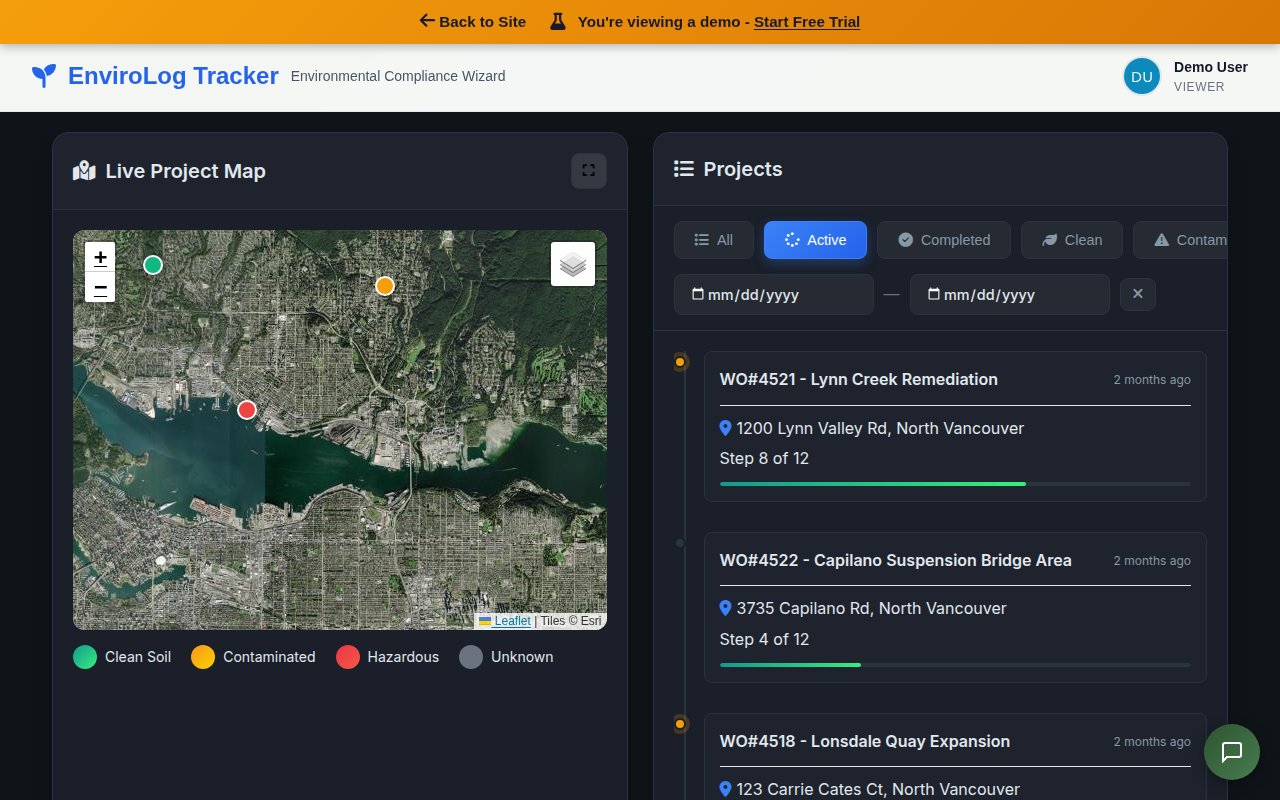
Geographic Information System (GIS) tools visualize contamination data on site maps, showing concentration contours, exceedance zones and monitoring well networks. NVES EnviroLog's built-in hazard mapping feature allows teams to overlay analytical data on aerial imagery for clear spatial understanding of contamination extent.
Laboratory Data Management
Electronic data deliverables (EDDs) from laboratories can be imported directly into compliance platforms, eliminating manual data entry and enabling automated comparison against regulatory standards. NVES EnviroLog supports direct lab data import with automatic exceedance flagging.
NVES EnviroLog provides end-to-end digital management for contaminated site assessments - from field data collection and chain of custody tracking through lab data import, regulatory comparison and compliance reporting. All data is stored securely in SOC 2 certified data centers.
Practical Guidance for Property Owners and Developers
Before You Buy
During Investigation
After Assessment
Frequently Asked Questions
See How EnviroLog Manages Assessments
Real software. Track projects, lab results and compliance from one dashboard.
Streamline Your Site Assessments
NVES EnviroLog manages chain of custody, lab data, hazard mapping and compliance reporting for contaminated site projects.
Request a Free Demo